by Heiko Liedeker, Abdullah Alwelaie and Ali As-Saifi
It is essential to realise that GIS will become more and more part of conservation infrastructures, designed to help facilitate conservation efforts. It certainly does not create solutions to problems in management, but it can provide the environment to derive the intelligence needed, so that managers can solve problems and make sound decisions.
Geographic Information Systems (GIS) are sets of analytical tools
to derive intelligent information from data. They provide a means
to evaluate surveys and to analyse changes that occur in space
and time. This is a considerable advance from the purely descriptive
geographic surveys which have been traditionally carried out.
The authors of this article have been applying the new techniques
to their conservation work in Saudi Arabia. Their report reviews
the function of GIS in conservation management and draws upon
their own work in this field.
International conservation efforts have increased dramatically
over the past two decades and scientifically based expert information
has provided the basis for much of these efforts. This information
is derived from data collected through surveys, monitoring and
research programmes. GIS is playing an increasingly vital role
in this process.
A Geographic Information System uses geographical reference as a common denominator to correlate and combine different thematic data. The GIS itself is neither a piece of hardware nor software, but an intricate analytical system carried out by highly qualified specialists using a variety of hardware and software tools. The degree of success is as much a function of the operator skills as of the other tools employed.
The first Geographic Information Systems appeared in the mid-1960's, parallel with the development of electronic data processing, and were designed to store and present geographic data. Precursors of modern day systems, they were however little more than sophisticated mapping methods. Throughout the 70's and 80's improvements were made to the basic GIS platforms through the addition of new data manipulation and analysis tools. Thus GIS evolved into coherent analytical systems capable undertaking quite sophisticated tasks in support of various types of surveys. The mass marketing of personal computers and development of fully functional PC-based GIS software has brought the technology to a much wider user-base so that it has revolutionised many of the complex tasks involved in land-use planning, urban development planning and conservation management.
Whereas up to now most GIS systems have not included a time-scale
in their analytical or manipulative procedures this is gradually
changing so that modelling and simulation of future trends can
be undertaken. In planning of future conservation efforts it is
increasingly important to be able to model ecosystems and predict
their dynamics in time so that likely changes may be predicted
and appropriate management plans adopted. In this way the work
of conservation managers will also change from one of reaction
to events that have already taken place, to a proactive role in
which predictable future trends provide the main basis for planning.
CLICK ON FIGURE THUMBNAILS FOR ENLARGED IMAGE (41 /68k JPEG)
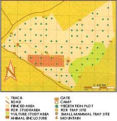 This can be illustrated by a practical example based upon our
work at Mahazat As-Sayd, a 2200 km2 reserve, east of the Asir
mountains, that was established in 1989 (fig 1). The reserve is
an important reintroduction site for Arabian oryx, sand gazelle,
houbara bustards and possibly red-necked ostrich. Fenced to prevent
incursion by domestic livestock or hunting activity, the vegetation
has shown a dramatic recovery following a prolonged period of
severe over-grazing. The reserve is an impressive conservation
project in which animals are well adapted and showing considerable
breeding success. But the conservation managers involved in the
project cannot simply rest on their laurels; they must instead
plan for the future. Such planning must address questions like:
how does vegetation recover?; how much biomass is produced annually?;
how fast to animal populations reproduce?;
This can be illustrated by a practical example based upon our
work at Mahazat As-Sayd, a 2200 km2 reserve, east of the Asir
mountains, that was established in 1989 (fig 1). The reserve is
an important reintroduction site for Arabian oryx, sand gazelle,
houbara bustards and possibly red-necked ostrich. Fenced to prevent
incursion by domestic livestock or hunting activity, the vegetation
has shown a dramatic recovery following a prolonged period of
severe over-grazing. The reserve is an impressive conservation
project in which animals are well adapted and showing considerable
breeding success. But the conservation managers involved in the
project cannot simply rest on their laurels; they must instead
plan for the future. Such planning must address questions like:
how does vegetation recover?; how much biomass is produced annually?;
how fast to animal populations reproduce?; 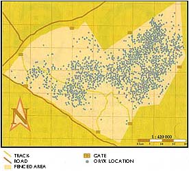 how many animals can be kept in the reserve?; and what happens
in period of prolonged drought? Each of these questions view the
ecosystem not as a fixed entity, but as one in which processes
and elements that form the ecosystem change with time. As we have
said already, it is the conservation manager's task to anticipate
the changes that are likely to occur.
how many animals can be kept in the reserve?; and what happens
in period of prolonged drought? Each of these questions view the
ecosystem not as a fixed entity, but as one in which processes
and elements that form the ecosystem change with time. As we have
said already, it is the conservation manager's task to anticipate
the changes that are likely to occur.
 Field-workers in Mahazat As-Sayd recorded over 15,000 oryx locations
in a two and a half year period, using visual sightings and radio
telemetry. To this mass of data will be added a vegetation survey
based upon a combination of conventional field-work, aerial photography
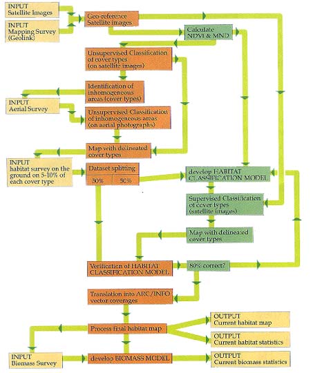
and satellite imagery. Figure 3 illustrates the data acquisition
process involved in the vegetation and biomass survey of the reserve.
This is where GIS really comes into its own for only such a complex
analytical tool will enable comparative analysis of both surveys,
thus linking oryx locations to spatial distribution of vegetation
in the reserve and enabling a detailed analysis of habitat preferences
to be conducted. The work will provide a basis for biomass modelling
that will simulate effects of increased grazing or prolonged drought.
Figure 4 schematically outlines the steps involved in the development
of such a biomass model. It is hoped in this way that we shall
eventually arrive at a carrying capacity model that will deal
with expanding wildlife populations and prevent permanent damage
to the vegetation resources.
Field-workers in Mahazat As-Sayd recorded over 15,000 oryx locations
in a two and a half year period, using visual sightings and radio
telemetry. To this mass of data will be added a vegetation survey
based upon a combination of conventional field-work, aerial photography
and satellite imagery. Figure 3 illustrates the data acquisition
process involved in the vegetation and biomass survey of the reserve.
This is where GIS really comes into its own for only such a complex
analytical tool will enable comparative analysis of both surveys,
thus linking oryx locations to spatial distribution of vegetation
in the reserve and enabling a detailed analysis of habitat preferences
to be conducted. The work will provide a basis for biomass modelling
that will simulate effects of increased grazing or prolonged drought.
Figure 4 schematically outlines the steps involved in the development
of such a biomass model. It is hoped in this way that we shall
eventually arrive at a carrying capacity model that will deal
with expanding wildlife populations and prevent permanent damage
to the vegetation resources.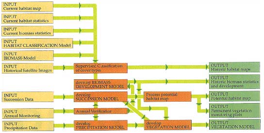
One of the potential catastrophes that could effect a reserve such as Mahazat As-Sayd is that of prolonged drought. The biomass simulation model will enable many vital questions to be answered, such as: how much vegetation will be left after two, three, four or even five years of drought?; how long will the remaining vegetation sustain the animal populations?; how much time will the vegetation need to recover?; or must the animal populations be reduced to ensure survival of a necessary minimum of vegetation resources? Given the complexity of the issues involved it seems imperative that instruments like modelling and simulation of ecosystem processes using GIS become regularly used tools in conservation management programmes. The decision to do so requires long term commitments of both people and financial resources.
Web Links | Subjects | Search
Arabian Wildlife. Volume 1, Number 2