The Geologic History
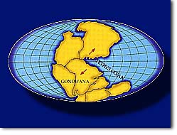
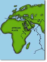 Geologically, the UAE occupies a corner of the Arabian Platform, a body of continental rock that has remained relatively stable since the Cambrian Period more than 500 million years ago. From a geological standpoint, the Arabian Platform encompasses not only present day Arabia but also the shallow Arabian Gulf (which is not a true ocean basin) and the rocks of the coastal Zagros Mountains of Iran. For most of its history, the Arabian Platform has been part of the larger Afro-Arabian continent, and the two have behaved as a unit in response to plate tectonic movements. Only about 25 million years ago, with the initial opening of the Red Sea, did Arabia begin to separate from the African plate. Movement of the Afro-Arabian plate during the Palaeozoic twice caused Arabia to pass near the South Pole (in the Ordovician and Carboniferous), and the UAE may have become glaciated. Since the end of the Palaeozoic, however, the UAE has remained in tropical or subtropical latitudes. Moreover, despite its travels, this area appears to have remained tectonically relatively stable, and the geologic history of the UAE has therefore been primarily a history of the advance and retreat of the sea. Geologically, the UAE occupies a corner of the Arabian Platform, a body of continental rock that has remained relatively stable since the Cambrian Period more than 500 million years ago. From a geological standpoint, the Arabian Platform encompasses not only present day Arabia but also the shallow Arabian Gulf (which is not a true ocean basin) and the rocks of the coastal Zagros Mountains of Iran. For most of its history, the Arabian Platform has been part of the larger Afro-Arabian continent, and the two have behaved as a unit in response to plate tectonic movements. Only about 25 million years ago, with the initial opening of the Red Sea, did Arabia begin to separate from the African plate. Movement of the Afro-Arabian plate during the Palaeozoic twice caused Arabia to pass near the South Pole (in the Ordovician and Carboniferous), and the UAE may have become glaciated. Since the end of the Palaeozoic, however, the UAE has remained in tropical or subtropical latitudes. Moreover, despite its travels, this area appears to have remained tectonically relatively stable, and the geologic history of the UAE has therefore been primarily a history of the advance and retreat of the sea.
Ancient sediments
 Over time, sediments accumulated on the coast and continental shelf that was to become the UAE. Limited pre-Permian exposures in the UAE reveal fine-grained, shallow water terrigenous sediments (silts and shales). These were probably relatively thin overall and may have been largely removed by intermittent emergence and erosion. Later, in the tropical Mesozoic seas, thick sequences of carbonate rocks, limestones (CaCO3) and dolomites (CaMg(CO3)2), were deposited. The late Permian and Mesozoic seas of the UAE were part of an ocean that opened north of Arabia during that time, separating the Afro-Arabian continent from the Eurasian continent. This palaeo-ocean is known to geologists as Tethys and at one time it extended westward to the present-day Mediterranean countries and eastward to the Himalayas. Over time, sediments accumulated on the coast and continental shelf that was to become the UAE. Limited pre-Permian exposures in the UAE reveal fine-grained, shallow water terrigenous sediments (silts and shales). These were probably relatively thin overall and may have been largely removed by intermittent emergence and erosion. Later, in the tropical Mesozoic seas, thick sequences of carbonate rocks, limestones (CaCO3) and dolomites (CaMg(CO3)2), were deposited. The late Permian and Mesozoic seas of the UAE were part of an ocean that opened north of Arabia during that time, separating the Afro-Arabian continent from the Eurasian continent. This palaeo-ocean is known to geologists as Tethys and at one time it extended westward to the present-day Mediterranean countries and eastward to the Himalayas.
Fossiliferous limestones and dolomites of Jurassic to late Cretaceous age (c.210 to c.85 million years ago) are the rocks in which the UAE's abundant oil reserves are typically found. Some of these rocks represent depositional environments very much like today's Arabian Gulf shores, but they are now buried at depths of approximately 2,400m to 7,000m. In particular, the lower part of the Mesozoic sequence includes sabkha deposits indicative of restricted ocean circulation.
Source of oil
Apart from the rocks of the Hajar Mountains, there is little surface outcrop of any kind throughout eastern Arabia, and most of what is known in detail of the geologic history of the Arabian Platform in this area comes from drilling and seismic information. Two persistent regional structural features noted by petroleum geologists are a major ridge running NE-SW through the Qatar peninsula and a parallel and adjacent major trough running through western Abu Dhabi and into the Empty Quarter. Subsurface structures may be very gentle, but gradients of as little as 2% can be sufficient to permit migration and entrapment of crude oil.
Vertical movement, salt domes and mountains.
The land emerged above sea level at various times throughout the earlier Mesozoic and Tertiary depositional history, but in the form of low lying land-masses, as occur today. These periods, when the sea did not cover the land, are evidenced by occasional breaks in the sedimentary record (formed by sand and mud being deposited on the sea-bed) and by sedimentary features indicating surface erosion, such as the development of palaeo-soils.
Since the mid-Cretaceous (c.100 million years ago), local topographic highs (and major structural traps for petroleum) have been created by salt domes rising from thick Cambrian salt deposits that underlie many areas of the southern Arabian Gulf at depths of more than 6,000m. Today these salt domes are responsible for certain coastal hills, such as Jebel Dhana and Jebel Ali, and for many of the UAE's offshore islands, such as Sir Bani Yas, Das, Zirku, and Sir Abu Nu'air.
Earth movements driven by plate tectonics caused the ocean floor of the deep ocean then lying to the north-east to be forced over the edge of the Arabian Platform and its cover of shallow water sediments. This process created a structure of massive superposed sheets (called 'nappes') of diverse rock types that now appear to have been shuffled, like cards, on a grand scale. This created the Hajar Mountains which possess the world's finest and most extensive surface exposure of rocks from the oceanic crust. Their present height and rugged topography is a product of renewed uplift and erosion due to regional forces commencing at the end of the Oligocene (c.25 million years ago) and continuing to the present. Geologically recent events such as Pleistocene glaciation and its associated effects on climate and sea level have put the finishing touches on the present day geology of the UAE as a whole.
|